
Full resolution (JPEG) - On this page / på denna sida - Forestry, by K. A. Fauchald
<< prev. page << föreg. sida << >> nästa sida >> next page >>
Below is the raw OCR text
from the above scanned image.
Do you see an error? Proofread the page now!
Här nedan syns maskintolkade texten från faksimilbilden ovan.
Ser du något fel? Korrekturläs sidan nu!
This page has been proofread at least once.
(diff)
(history)
Denna sida har korrekturlästs minst en gång.
(skillnad)
(historik)
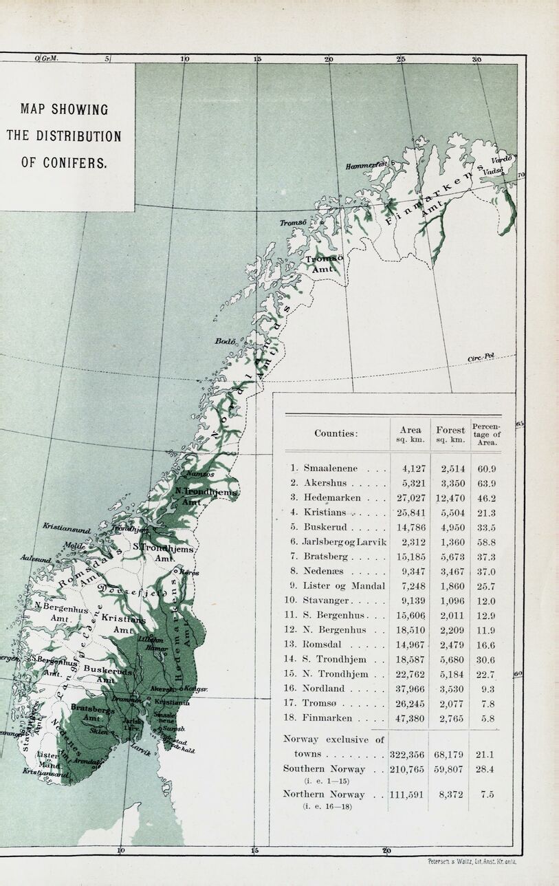
MAP SHOWING
THE DISTRIBUTION
OF CONIFERS.
 |
| Petersen & Waitz, Lit. Anst. Kr.ania. |
| Counties: | Area sq. km. | Forest sq. km. | Percentage of Area. | |
| 1. | Smaalenene . . . | 4,127 | 2,514 | 60.9 |
| 2. | Akershus ..... | 5,321 | 3,350 | 63.9 |
| 3. | Hedemarken . . . | 27,027 | 12,470 | 46.2 |
| 4. | Kristians ...... | 25,841 | 5,504 | 21.3 |
| 5. | Buskerud ..... | 14,786 | 4,950 | 33.5 |
| 6. | Jarlsberg og Larvik | 2,312 | 1,360 | 58.8 |
| 7. | Bratsberg ..... | 15,185 | 5,673 | 37.3 |
| 8. | Nedenæs ..... | 9,347 | 3,467 | 37.0 |
| 9. | Lister og Mandal | 7,248 | 1,860 | 25.7 |
| 10. | Stavanger ..... | 9,139 | 1,096 | 12.0 |
| 11. | S. Bergenhus . . . | 15,606 | 2,011 | 12.9 |
| 12. | N. Bergenhus . . | 18,510 | 2,209 | 11.9 |
| 13. | Romsdal ..... | 14,967 | 2,479 | 16.6 |
| 14. | S. Trondhjem . . | 18,587 | 5,680 | 30.6 |
| 15. | N. Trondhjem . . | 22,762 | 5,184 | 22.7 |
| 16. | Nordland ..... | 37,966 | 3,530 | 9.3 |
| 17. | Tromsø ...... | 26,245 | 2,077 | 7.8 |
| 18. | Finmarken .... | 47,380 | 2,765 | 5.8 |
| Norway exclusive of
towns ........ | 322,356 | 68,179 | 21.1 | |
| Southern Norway . .
(i. e. 1-15) | 210,765 | 59,807 | 28.4 | |
| Northern Norway
(i. e. 16—18) | 111,591 | 8,372 | 7.5 | |
<< prev. page << föreg. sida << >> nästa sida >> next page >>