
Full resolution (TIFF) - On this page / på denna sida - N:o 2 - Pages ...
<< prev. page << föreg. sida << >> nästa sida >> next page >>
Below is the raw OCR text
from the above scanned image.
Do you see an error? Proofread the page now!
Här nedan syns maskintolkade texten från faksimilbilden ovan.
Ser du något fel? Korrekturläs sidan nu!
This page has never been proofread. / Denna sida har aldrig korrekturlästs.
FENNIA 66, N:o 1
9
its elevation is far greater in the north-west than in the south-east.
The warping and tilting are shown in detail by the isobases.
RECENT WARPING OF SOUTHERN FINLAND.
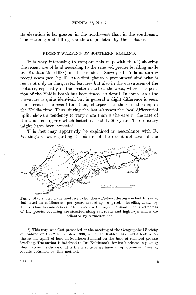
It is very interesting to compare this map with that showing
the recent rise of land according to the renewed precise levelling made
by Kukkamäki (1938) in the Geodetic Survey of Finland during
recent years (see Fig. 6). At a first glance a pronounced similarity is
seen not only in the greater features but also in the curvatures of the
isobases, especially in the western part of the area, where the
position of the Yoldia beach has been traced in detail. In some cases the
curvature is quite identical, but in general a slight difference is seen,
the curves of the recent time being sharper than those on the map of
the Yoldia time. Thus, during the last 40 years the local differential
uplift shows a tendency to vary more than is the case in the rate of
the whole emergence which lasted at least 12 000 years! The contrary
might have been expected.
This fact may apparently be explained in accordance with R.
Witting’s views regarding the nature of the recent upheaval of the
Fig. 6. Map showing the land rise in Southern Finland during the last 40 years,
indicated in millimetres per year, according to precise levelling made by
Dr. Kukkamäki and others in the Geodetic Survey of Finland. The fixed points
of the precise levelling are situated along rail-roads and highways which are
indicated by a thicker line.
This map was first presented at the meeting of the Geographical Society
of Finland on the 21st October 1938, when Dr. Kukkamäki held a lecture on
the recent uplift of land in Southern Finland on the base of renewed precise
levelling. The author is indebted to Dr. Kukkamäki for his kindness in placing
this map at his disposal. It is the first time we have an opportunity of seeing
results obtained by this method.
5172,—38
2
<< prev. page << föreg. sida << >> nästa sida >> next page >>