Full resolution (JPEG) - On this page / på denna sida - Sidor ...

<< prev. page << föreg. sida << >> nästa sida >> next page >>
Below is the raw OCR text
from the above scanned image.
Do you see an error? Proofread the page now!
Här nedan syns maskintolkade texten från faksimilbilden ovan.
Ser du något fel? Korrekturläs sidan nu!
This page has never been proofread. / Denna sida har aldrig korrekturlästs.
11
Samme Dag- Kl. 6.1ä Min. til 7.5 Min. Eft. Kaal
No. 1. C. Wille.
« = 72° 43/9.
1876, Juni 15. Kl. 10.55 Min. til 11.53 Min. Form.
Naal No. 1. H. Mohn.
H — 72° 46/02.
Samme Dag. Kl. 7.7 Min. til 7.32 Min. Ett. Naal
No. 2. H. Mohn.
H = 72° 45/05.
1877, Maj 23. Kl. 5.U Min. til 6.45 Min, Eft. Naal
No. 1. C. Wille.
H = 72° 43/35.
Same Day: — 6.15 p. m. to 7.5 p. m. Needle No.
1. C. Wille.
H = 72° 43/9. f
1876. June 15: — 10.55 a. ni. to 1153 a. m. Needle
No. 1. H. Mohn.
6 = 72° 46/02.
Same Day: — 7.7 p. m. to 7.32 p. m. Needle No.
2. H. Mohn.
ß = 72° 45/05.
1877., May 23: — 5.0 p. m. to 6.45 p. m.’ ’Needle
No. 1. C.’Wille.
’ H = 72° 43/35.
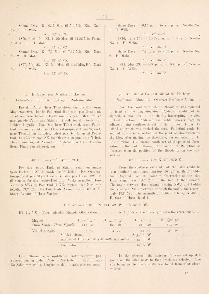
ß. Et Skjær paa Østsiden af Havnen.
Deklination. Juni 16. Iagttager: Professor Mohn.
Fra det Punkt, hvor Theodoliten var opstillet foran
Magnetometret, kunde Poldetind ikke sees paa Grund af.
at et nærmere liggende Fjeld kom i Vejen. Men fra et
nærliggende Punkt paa Skjæret, i SSE for det förste, vår
Poldetind synlig. Paa Øen, hvor Teltet stod. saaes
Poldetind i samme Vertikal som Observationspunktet paa Skjæret,
naar Theodoliten flyttedes, lodret paa Synslinien til
Poldetind. 41.4 Meter mod SE fra Observationspunktet i Teltet.
Heraf beregnes, at Azimut af Poldetind; seet fra
Theoclo-litens Plads paa Skjæret, var
48° 7/6 — 7.’7 47° 59/9 E,
Fra den søndre Ende af Skjæret saaes en anden
fjern Fjeldtop 10° 25’ nordenfor Poldetind. Fra
Observationspunktet paa Skjæret saaes Varden paa Husø 182° 27’
til venstre for den nævnte Fjeldtop. Vinkelen mellem Husø
Varde (i SW) og Poldetind (i NE) regnet over Nord var
følgelig 192° 52’. Da Poldetinds Azimut var N 48" 0’ É.
bliver Azimut af Husø Varcle:
Kl
Declination
Om Eftermiddagen opstilledes Instrumenterne paa
Skjæret paa en anden Plads, i Nærheden af den ’
forrige.-l.)a Solen var synlig, benyttedes den til Azimutbestemmelse.
ß. An Islet at the east side of the Hnrbour.
Declination. "June 16. Observer Professor Mohn.
From the point at which the theodolite was mounted
in front of the magnetometer. Poldetind could not be
sighted, a mountain in the vicinity intercepting the view
in that direction. Poldetind was visible however from an
adjapent point south-south-eäst of the former. From the
island on which was pitched, the tent, Poldetind could be
sighted in the same vertical as the point of observation on
the islet, after moving the theodolite, perpendicular to the
line of vision. 41.4 metres south-east of the point of
observation in the tent. Hence, the azimuth of Poldetind as
observed from the position of the theodolite on the islet,
was —
48° 7/6 — 7/7 = N 47° 59/9 E
From the southern extremity of the islet could be
seen another distant mountain-top.’ 10° 25’ north of
Poldetind. Sighted from the point of observation on the islet.
Husø signal was 182° 27’ to the left of that summit.
The angle between Husø signal (bearing SW.) and
Poldetind (bearing NE.) reckoned through the north, was
accordingly 192° 52’. The azimuth of Poldetind being N 48" 0’
E. that of Husø signal is —
At 11.15 a. m. the following observations were made: —
19° o’ W
In the afternoon the instruments were set up at a
point on the islet near to that previously selected. The
sun being visible, the azimuth was found from solar
observations.
9*
192° 52’ — 48° 0’ - X. 144° 52’ W = S 35" 8’ W.
. 11.15 Min. Form, gjordes følgende Observationer:
Magnet I 159° 31’ H 339° 3’ I i59° 4’ H 158’ 50’
Husø Varde (Husø Sir/nal) 213 30 393 30 ’ 213 30 213-30
Yinkel (Angle) 53 59 . 54 27 54 26 54 40
Middel (Mean) S 54° 8’ W
Azimut af Husø Varde (Azimuth of Signal) S 35 8 W
<< prev. page << föreg. sida << >> nästa sida >> next page >>