
Full resolution (JPEG) - On this page / på denna sida - Sidor ...
<< prev. page << föreg. sida << >> nästa sida >> next page >>
Below is the raw OCR text
from the above scanned image.
Do you see an error? Proofread the page now!
Här nedan syns maskintolkade texten från faksimilbilden ovan.
Ser du något fel? Korrekturläs sidan nu!
This page has never been proofread. / Denna sida har aldrig korrekturlästs.
Havvandets Tæthed, som atmosfæriske Aarsager fremkalde
paa de forskjellige Steder.
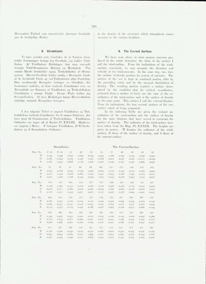
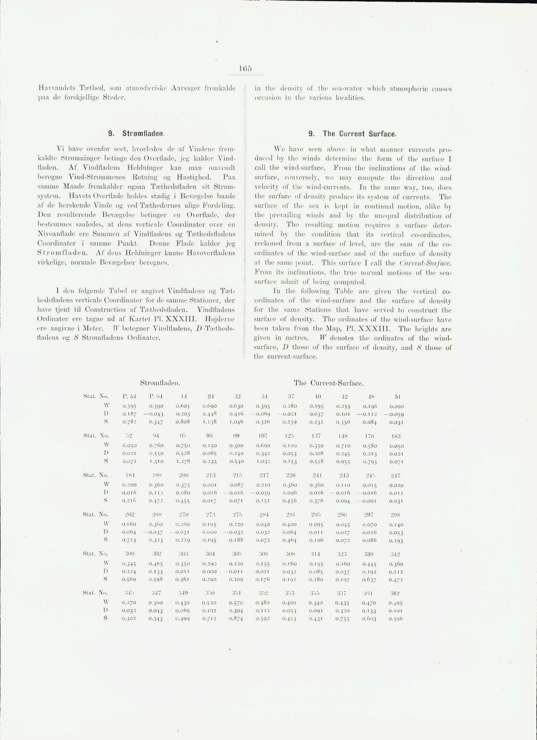
9. Strømfladen.
Vi have ovenfor seet, hvorledes de af Vindene
fremkaldte Strømninger betinge den Overflade, jeg kalder
Vind-fladen. Af Vindfladens Heldninger kan man omvendt
beregne Vind-Strømmenes Retning og Hastighed. Paa
samme Maade fremkalder ogsaa Tæthedsfladen sit
Strømsystem. Havets Overflade holdes stadig i Bevægelse baade
af de herskende Vinde og ved Tæthedernes ulige Fordeling.
Den resulterende Bevægelse betinger en Overflade, der
bestemmes saaledes, at dens vertieale Coordinater over en
Niveauflade ere Summen af Vindfladens og Tæthedsfladens
Coordinater i samme Punkt. Denne Flade kalder jeg
S trom fladen. Af dens Heldninger kunne Havoverfladens
virkelige, normale Bevægelser beregnes.
1 den følgende Tabel er angivet Vindfladens og
Tæt-hedsiladens vertieale Coordinater for de gamme Stationer, der
have tjent til Construction af Tæthedsfladen. Vindfladens
Ordinater ere tagne ud af Kartet PI. XXXIII. Højderne
ere angivne i Meter. 1K betegner Vindfladens, D
•Tætheds-fladens og S Strømfladens Ordinater.
in the density of the sea-water which atmospheric causes
occasion in the various localities.
9. The Current Surface.
We have seen above in what manner currents
produced by the winds determine the form of the surface I
call the wind-surface. From the inclinations of the
wind-surface, conversely, we may compute the direction and
velocity of the wind-currents. In the same way, too, does
the surface of density produce its system of currents. The
surface, of the sea is kept in continual motion, alike by
the prevailing winds and by the unequal distribution of
density. The resulting motion requires a surface
determined by the condition that its vertical co-ordinates,
reckoned from a surface of level, are the sum of the
coordinates of the wind-surface and of the surface of density
at the same point. This surface I call the Current Surface.
From its inclinations, the true normal motions of the
sea-surface admit of being computed.
In the following Table are given the vertical
coordinates of the wind-surface and the surface of density
for the same Stations that have served to construct the
surface of density. The ordinates of the wind-surface have
been taken from the Map, Pl. XXXIII. The heights are
given in metres. W denotes the ordinates of the
wind-surface, D those of the surface of density, and S those of
the current-surface.
StromHa.de ill. The Curr ent-Surface.
Ståt. No. P. 54 P. H4 14 24 32 34 37 10 42 48 51
W 0.595 0.390 0.605 0.690 0.630 0-395 0.280 0.195 0.255 0.196 0.090
1) 0.187 —0.043 0.203 0.448 0.416 0.069 —0.021 0.037 0.101 — -0.112 —0.059
S 0.782 0.347 0.808 1.138 1.046 0.326 0.259 0.232 0.356 0.084 0.031
Ståt. No. r>2 94 sir, 90 99 107 125 137 148 170 183
W 0.050 0.760 0.750 0.150 0.300 0.690 0.100 0.350 0.710 0.580 0.050
D 0.021 0-550 0.528 0.085 0.240 0.342 0.053 0.208 0.245 0.213 0.021
S 0.071 1.310 1.278 0.235 0.540 1.032 0.153 0.558 0-955 0.793 0.071
Ståt, No. 184 1 it!) 20(5 213 21 r» 217 226 241 243 245 247
W 0.200 0.360 0.375 0.001 0.087 0.210 0.360 0.360 0.110 0.015 0.020
I) 0.016 0.112 0.080 0.016 —0.016 —0.059 0.096 0.016 —0.016 — -0.016 o.oi i
S 0.216 O.472 0-455 0.017 0.071 0.151 0.456 0.376 0.094 - -0.001 0.031
Ståt, No. •202 208 270 27:5 275 284 29.1 295 29(i 297 298
W 0.660 0.360 0.260 0.195 0.220 0.040 0.400 0 095 0.045 0.070 0.140
D 0.064 —O.037 - -0.031 0.000 —0.032 0.032 0.064 o.oi i 0.027 0.016 0.053
S 0.724 O.323 0.229 0.195 0.188 0.072 0.464 0.106 0.072 0.086 0.193
Ståt. No. 300 302 :to:i 304 305 sou 308 314 :i*> 339 342
W’ 0.345 0.465 0.350 0.290 0.220 0.155 0.160 0.195 0.160 0.445 0.360
D 0.224 0.133 o.oi i 0.000 —o.oi i 0.021 0.032 0.085 0.037 0.192 o.i 12
S 0.569 0.598 0.361 0.290 0.209 O.i76 0.192 0.280 0.197 0.637 0.472
Ståt, No. 345 347 349 350 351 352 3T.3 355 357 3’il 362
W 0.270 0.300 0.430 0.520 0.570 0.480 O.4oo 0.340 0.435 0.470 0.495
D 0.032 0.043 0.069 0.192 0.304 O.I 12 O.O53 0.091 0.320 O.133 O.IOI
S 0.302 0-343 0.499 0.712 0.874 0.592 O.453 0.431 0.755 0.603 0.596
<< prev. page << föreg. sida << >> nästa sida >> next page >>