
Full resolution (JPEG) - On this page / på denna sida - I. Physical Geography. Introd. by [G. Sundbärg] Gunnar Andersson - 2. Hydrography. By A. Wallén

<< prev. page << föreg. sida << >> nästa sida >> next page >>
Below is the raw OCR text
from the above scanned image.
Do you see an error? Proofread the page now!
Här nedan syns maskintolkade texten från faksimilbilden ovan.
Ser du något fel? Korrekturläs sidan nu!
This page has never been proofread. / Denna sida har aldrig korrekturlästs.
hydrowkaphy. 21
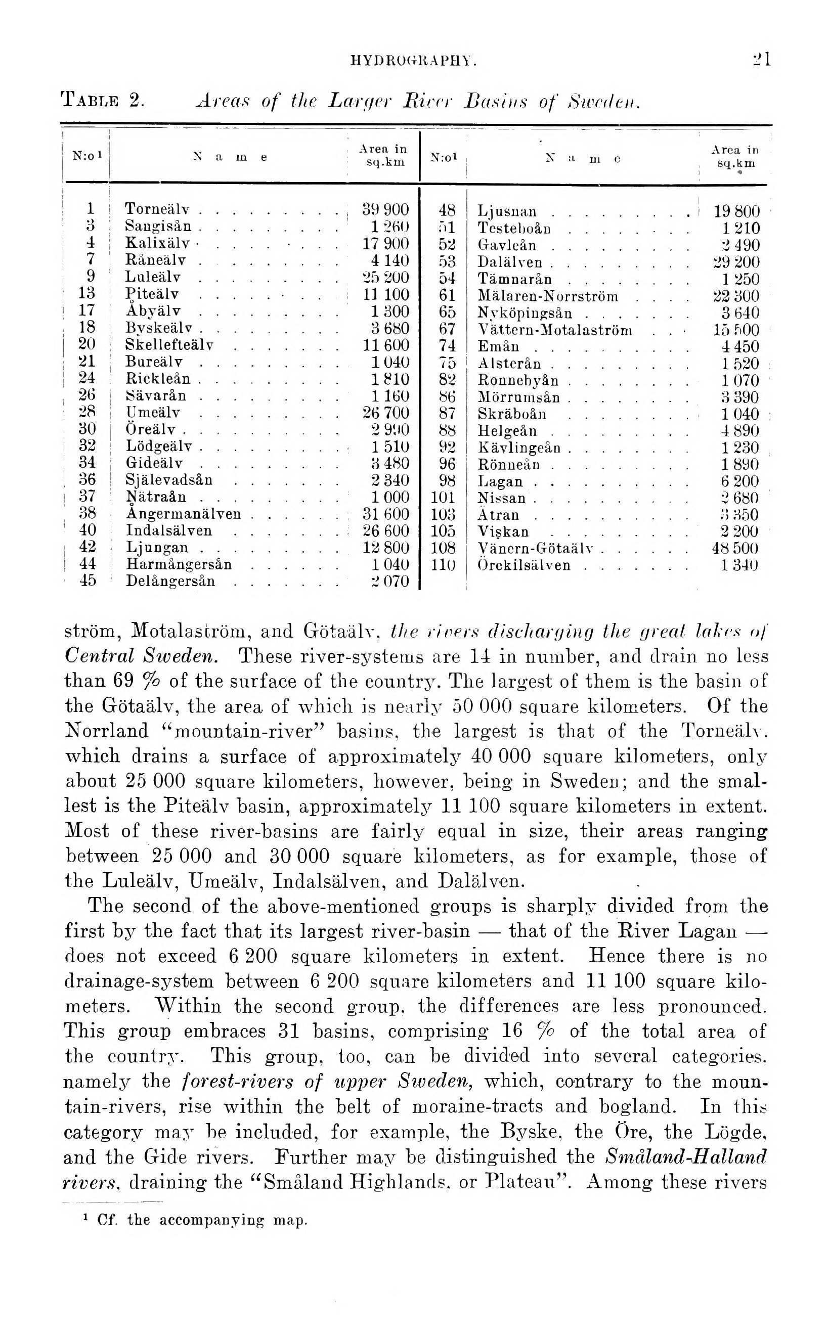
Table 2. Area,s of the La-ryet Pärer Basins of Sweden.
N:o 1 X a ni e Area in sq .kui
1 Torneälv....... . . , 39 900
3 Sangisån....... . . 1 260
4 Kalixälv ■ .... • . 17 900
7 1 Råneälv...... . . 4 14(1
9 Luleälv....... . . 25 200
13 Piteälv..... 11 100
17 Abvälv....... . . 1 300
18 Bvskeälv....... 3 680
I 20 Skellefteälv..... . . 11600
21 Bureälv....... . . 1040
24 Rickleàn....... 1810
26 Sävarån....... 1 160
28 1’meälv....... . . 26 700
30 I heal v........ . . 2 990
32 Lödgeälv....... 1 510
34 Gideälv....... 3 480
36 Själevadsån ..... . . 2 340
37 Nätraån....... 1 000
38 Angermanälven .... . . 31600
40 Indalsälven..... . . 26 600
42 Ljungan ....... . . 12 800
44 Harmångerån .... . . 1 040
45 Delångersån..... . . 2 070
48 Ljusnan......... 19 800
öl Testeboån..... . . 1210
52 Gaväeån..................2 490
53 Dalälven..................29 200
54 Tämnarån................1 250
61 Mälaren-Norrström .... 22300
65 Nyköpingsån..............3 640
67 Vättern-Motalaström . . • 15 500
74 Em ån....................4 450
75 Alsterån..................1520
82 Ronnehyån..............1070
86 Mörrnmsån................3 390
87 Skräboån ................1040
88 Helgeån..................4 890
92 I Kävlingeån................1 230
96 Rönneåu..................18ü0
98 Lagan....................6 200
101 Nissan....................2 680
103 : Ätran....................i! H50
105 i Viskan ..................2 200
108 Vänern-Götaälv............48 500
HU I Örekilsälven..............1 340
ström, Motalaström, and Götaälv, the times discharging the ureal lakes of
Central Sweden. These river-systems are 11 in nirmber, and drain no less
than 69 Jo of the surface of the country. The largest of them is the basin of
the Götaälv, the area of which is nearly 50 000 square kilometers. Of the
Norrland "mountain-river" basins, the largest is that of the Torneälv.
which drains a surface of approximately 40 000 square kilometers, only
about 25 000 square kilometers, however, being in Sweden; and the
smallest is the Piteälv basin, approximately 11 100 square kilometers in extent.
Most of these river-basins are fairly equal in size, their areas ranging
between 25 000 and 30 000 square kilometers, as for example, those of
the Luleälv, Umeälv, Indalsälven, and Dalälven.
The second of the above-mentioned groups is sharply divided from the
first by the fact that its largest river-basin — that of the River Lagan —
does not exceed 6 200 square kilometers in extent. Hence there is no
drainage-system between 6 200 square kilometers and 11 100 square
kilometers. Within the second group, the differences are less pronounced.
This group embraces 31 basins, comprising 16 % of the total area of
the counlry. This group, too, can be divided into several categories,
namely the forest-rivers of upper Siveden, which, contrary to the
mountain-rivers, rise within the belt of moraine-tracts and bogland. In this
category may be included, for example, the Byske, the Öre, the Lögde,
and the Gide rivers. Further may be distinguished the Småland-Hedland
rivers, draining the "Småland Highlands, or Plateau". Among these rivers
1 Cf. the accompanying map.
<< prev. page << föreg. sida << >> nästa sida >> next page >>