
Full resolution (JPEG) - On this page / på denna sida - Sidor ...
<< prev. page << föreg. sida << >> nästa sida >> next page >>
Below is the raw OCR text
from the above scanned image.
Do you see an error? Proofread the page now!
Här nedan syns maskintolkade texten från faksimilbilden ovan.
Ser du något fel? Korrekturläs sidan nu!
This page has never been proofread. / Denna sida har aldrig korrekturlästs.
17
Efter de norske Kystkarter ligger Vardøhus paa:
Bredden 70° 22’ 5"
Længden 31° 7’ -35" = 2* £n 30/3 E. Greenwich.
Efter en senere fundet Correction for en Regnefejl
skulde imidlertid Punkterne østenfor Nordkap ligge c. 22"
østligere end i Kartet, altsaa Vardøhus paa Længden 31"
7’ 57" = 2A 4’" 31/8. hvilken Værdi kun er 6" eller
(»."4 større end den af mig fundne.
Sammenstilles de af mig fundne Længder med de
paa de norske Kystkarter udmaalte. faar man følgende
Oversigt:
On the Norwegian coastal charts. Vardøhus is in
Latitude 70" 22’ 5"
Longitude 31° 7’ 35" = 2A 4™ 30/3 E. Greenwich.
Meanwhile, the points east of the North Cape should,
according to an error of calculation subsequently discovered,
, lie about 22" farther east than on the chart. Vardøhus
therefore in longitude 31" 7’ 57" = 2A 4m 31/8; and this
value exceeds my determination by only 6". or 0/4.
A comparison between my determinations of longitude
and those on the respective Norwegian charts gives the
following results: —
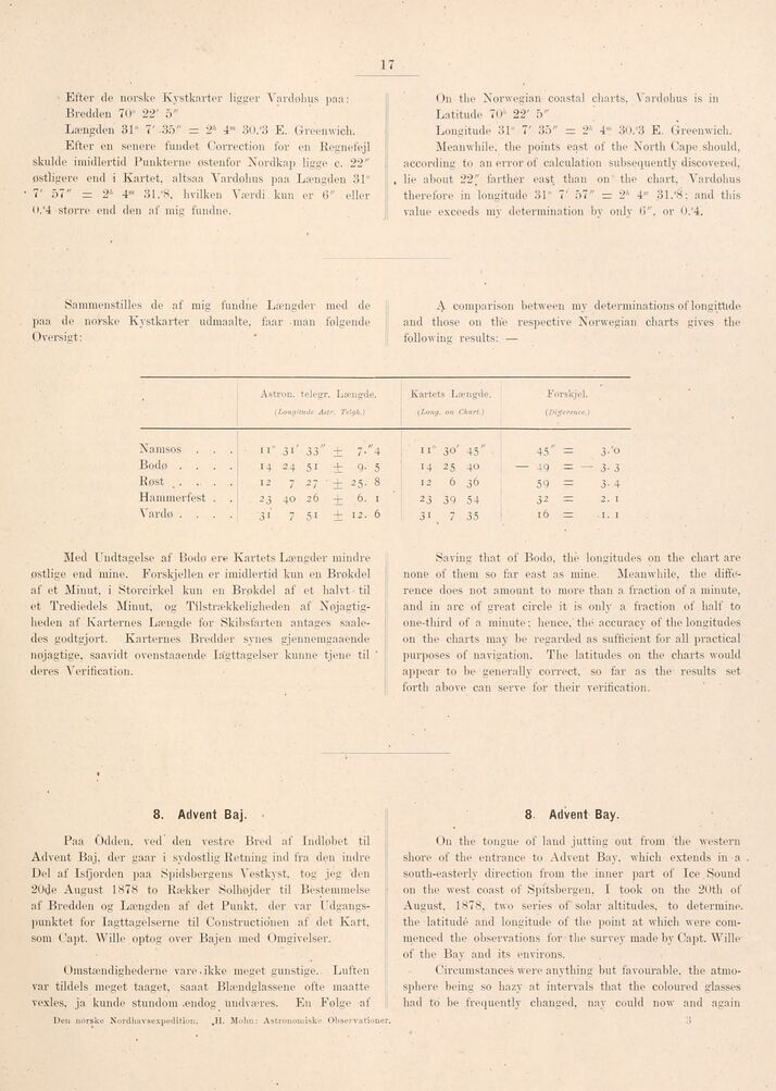
Astrou. telegr. Længde. Kartets Længde. Forskjel.
(Lon,i tude Astr. Telgh.) (Long. on Chart.) (Difference.)
Namsos . . . II" 31’ 33" ± i’ "4 11" 30’ 45" • 45" S 3-’o
Bodo . . . . 14 24 SI + 9- 5 14 25 40 — 49 = — 3- 3
Eost . . . . . 12 7 2 7 ’ + 25- 8 12 6 36 59 = 3- 4
Hammerfest . . 23 40 26 ± 6- I 23 39 54 32 — 2. I
Vardø . . . . 31 7 51 i I2- 6 31 7 35 16 = ■ I. I
Med Undtagelse af Bodø ere Kartets Længder mindre
østlige end mine. Forskjellen er imidlertid kun en Brøkdel
af et Minut, i Storcirkel kun en Brøkdel af et halvt til
et Trediedels Minut, og Tilstrækkeligheden af
Nøjagtigheden af Karternes Længde for Skibsfarten antages
saaledes godtgjort. Karternes Bredder synes gjennemgaaende
nøjagtige, saavidt ovenstaaende Ia’gttagelser kunne tjene til
deres Verification.
Saving that of Bodø. the longitudes on the chart are
none of them so far east as mine. Meanwhile, the
difference does not amount to more than a fraction of a minute,
and in arc of great circle it is only a fraction of half to
one-third of a minute; hence.’ the accuracy of the longitudes
on the charts may be regarded as sufficient for all practical
purposes of navigation. The latitudes on the charts would
appear to be generally correct, so far as the results set
forth above can serve for their verification.
8. Advent Baj.
Paa Odden, ved den vestre Bred af Indløbet til
Advent Baj. der gaar i sydostlig Retning ind fra den indre
Del af Isfjorden paa Spidsbergens Vestkyst, tog jeg den
20de August 1878 to Rækker Solhøjder til Bestemmelse
af Bredden og Længden af det Punkt, der var
Udgangspunktet for Iagttagelserne til Constructionen af det Kart.
som Capt. Wille optog over Bajen med Omgivelser.
Omstændighederne vare.ikke meget gunstige. Luften
var tildels meget taaget, saaat Blændglassene ofte maatte
vexles, ja kunde stundom .endog undværes. En Følge af
Den norske Nordhavsexpedition. ,H. Mohn: Astronomiske Observation!
8 Advent Bay.
On the tongue of land jutting out from the western
shore of the entrance to Advent Bay. which extends in a
south-easterly direction from the inner part of lee Sound
on the west coast of Spitsbergen. I took on the 20th of
August. 1878, two series of’ solar altitudes, to determine,
the latitude and longitude of the point at which were
commenced the observations for the survey made by Capt. Wille
of the Bay and its environs.
Circumstances were anything but favourable, the
atmosphere being so hazy at intervals that the coloured glasses
had to be frequently changed, nay could now and again
<< prev. page << föreg. sida << >> nästa sida >> next page >>