
Full resolution (JPEG) - On this page / på denna sida - I. Physical Geography. Introd. by [G. Sundbärg] Gunnar Andersson - 2. Hydrography. By A. Wallén
<< prev. page << föreg. sida << >> nästa sida >> next page >>
Below is the raw OCR text
from the above scanned image.
Do you see an error? Proofread the page now!
Här nedan syns maskintolkade texten från faksimilbilden ovan.
Ser du något fel? Korrekturläs sidan nu!
This page has never been proofread. / Denna sida har aldrig korrekturlästs.
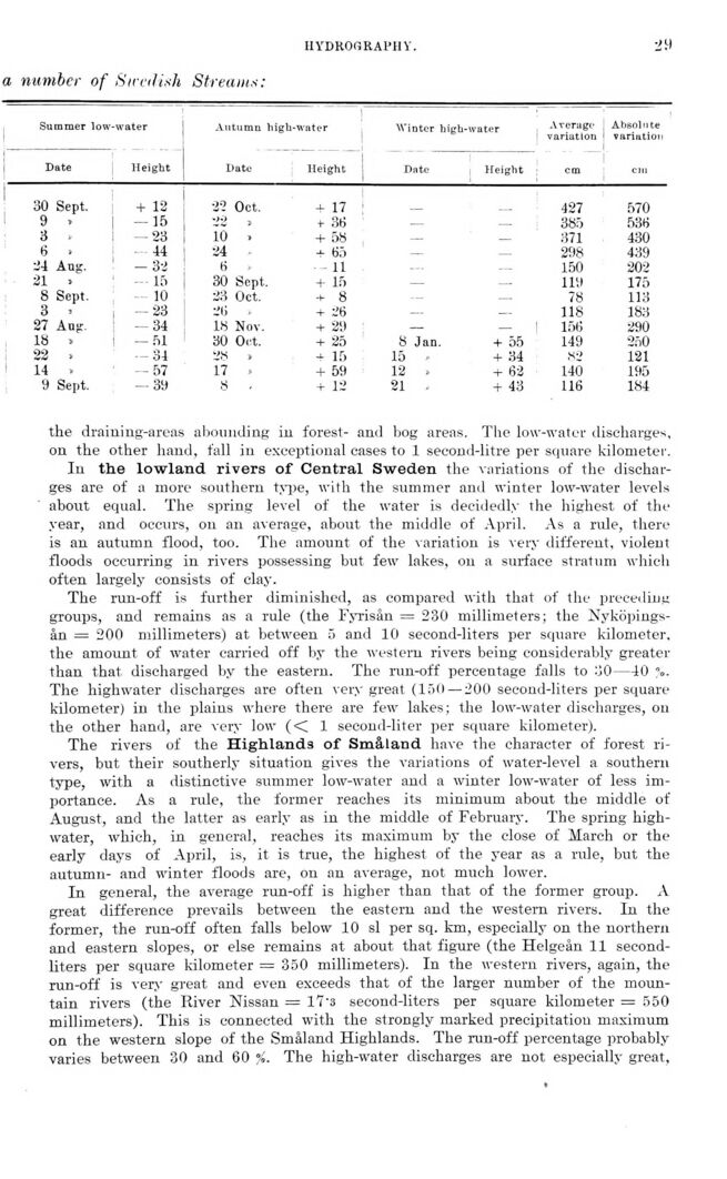
HYDROGRAPHY.
■i 9
a number of SimUsh Streams
Summer low-water Autumn high-water Winter hieh-water Average Absoln
variation vari uti
Date Height Date Height Date Height ___ cm cm
30 Sept. + 12 22 Oct. + 17 427 570
9 , -15 22 » +- 36 ___ 385 536
3 — 23 10 > + 58 — — 371 430
6 v 44 24 + 65 — — 298 439
24 Aug. -32 6 , 11 WH 150 202
21 » —15 30 Sept. + 15 — - 119 175
8 Sept. 10 23 Oct. + 8 — 78 113
3 « -23 26 - + 26 — - 118 183
27 Aup. — 34 18 Nov. + 29 — - 156 290
18 > — 51 30 Oct. + 25 8 Jan. + 55 149 250
22 » — 34 28 » -i- 15 15 * + 34 82 121
14 - — 57 17 + 59 12 » + 62 140 195
9 Sept. — 39 8 . + 12 21 + 43 116 184
the draining-areas abounding in forest- and bog areas. The low-watg® discharges,
on the other hand, fall in exceptional cases to 1 second-litre per square kilometer.
In the lowland rivers of Central Sweden the variations of the
discharges are of a more southern type, with the summer and winter low-water levels
about equal. The spring level of the water is decidedly the highest of the
year, and occurs, on an average, about the middle of April. As a rule, there
is an autumn flood, too. The amount of the variation is very different, violent
floods occurring in rivers possessing but few lakes, on a surface stratum which
often largely consists of clay.
The run-off is further diminished, as compared with that of the preceding
groups, and remains as a rule (the Fyrisån = 230 millimeters; the
Nyköpingsån = 200 millimeters) at between 5 and 10 second-liters per square kilometer,
the amount of water carried off by the western rivers being considerably greater
than that discharged by the eastern. The run-off percentage falls to o0—40 <v
The highwater discharges are often very great (150 — 200 second-liters per square
kilometer) in the plains where there are few lakes; the low-water discharges, on
the other hand, are very low (< 1 second-liter per square kilometer).
The rivers of the Highlands of Småland have the character of forest
rivers, but their southerly situation gives the variations of water-level a southern
type, with a distinctive summer low-water and a winter low-water of less
importance. As a rule, the former reaches its minimum about the middle of
August, and the latter as early as in the middle of February. The spring
high-water, which, in general, reaches its maximum by the close of March or the
early days of April, is, it is true, the highest of the year as a rule, but the
autumn- and winter floods are, on an average, not much lower.
In general, the average run-off is higher than that of the former group. A
great difference prevails between the eastern and the western rivers. In the
former, the run-off often falls below 10 si per sq. km, especially on the northern
and eastern slopes, or else remains at about that figure (the Helgeån 11
second-liters per square kilometer = 350 millimeters). In the western rivers, again, the
run-off is very great and even exceeds that of the larger number of the
mountain rivers (the River Nissan = 17’3 second-liters per square kilometer = 550
millimeters). This is connected with the strongly marked precipitation maximum
on the western slope of the Småland Highlands. The run-off percentage probably
varies between 30 and 60 %. The high-water discharges are not especially great,
<< prev. page << föreg. sida << >> nästa sida >> next page >>