
Full resolution (JPEG) - On this page / på denna sida - I. Physical Geography. Introd. by [G. Sundbärg] Gunnar Andersson - 2. Hydrography. By A. Wallén
<< prev. page << föreg. sida << >> nästa sida >> next page >>
Below is the raw OCR text
from the above scanned image.
Do you see an error? Proofread the page now!
Här nedan syns maskintolkade texten från faksimilbilden ovan.
Ser du något fel? Korrekturläs sidan nu!
This page has never been proofread. / Denna sida har aldrig korrekturlästs.
It) I. PHYSICAL GEOGRAPHY.
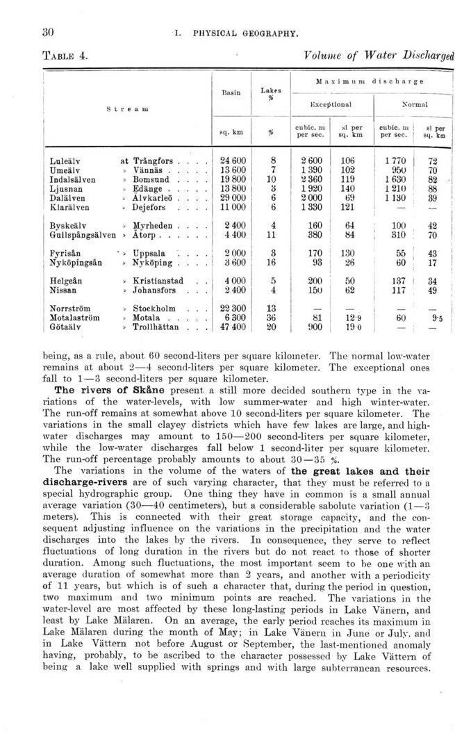
Table 4. Volume of Water Discharged
s t r a m Basin Lakes * Maximum Exceptional lischarge Normal
sq. km % cubic, m per sec. si per sq. km cubic, m per sec. si per sq. km
Luleälv at Trångfors .... 24 600 8 2 600 106 1770 72
Umeälv s Vännäs..... 13 600 7 1390 102 950 70
Indalsälven J Bomsund .... 19 800 10 2 360 119 1630 82 ■
Ljusnan I, Edänge ..... 13 800 3 1920 140 1210 88
Dalälven v Alvkarleö .... 29 000 6 2 000 69 1 130 39
Klarälven » Dejefors .... 11000 6 1330 121 — —
Byskeälv „ Mvrheden .... 2 400 4 160 64 100 42
Gullspångsälven Åtorp...... 4 400 11 380 84 310 70
Fyrisån Uppsala .... 2 000 3 170 130 55 43 j
Nyköpingsån Nyköping .... 3 600 16 93 26 60 17
Helgeån i> Kristianstad . . 4 000 5 200 50 137 34
Nissan » Johansfors . . . 2 400 4 150 62 117 49
Norrström J Stockholm . . . 22 300 13 __ _ _
Motalaström > Motala..... 6 300 36 81 12’9 60 9-5
Götaälv * Trollhättan . . . 47 400 20 900 19 0 — —
being, as a rale, about 60 second-liters per square kilometer. Tlie normal low-water
remains at about 2—4 second-liters per square kilometer. The exceptional ones
fall to 1 — 3 second-liters per square kilometer.
The rivers of Skåne present a still more decided southern type in the
variations of the water-levels, with low summer-water and high winter-water.
The run-off remains at somewhat above 10 second-liters per square kilometer. The
variations in the small clayey districts which have few lakes are large, and
high-water discharges may amount to 150—200 second-liters per square kilometer,
while the low-water discharges fall below 1 second-liter per square kilometer.
The run-off percentage probably amounts to about 30 — 35 %.
The variations in the volume of the waters of the great lakes and their
diseharge-rivers are of such varying character, that they must be referred to a
special hydrographic group. One thing they have in common is a small annual
average variation (30—40 centimeters), but a considerable sabolute variation (1 — 3
meters). This is connected with their great storage capacity, and the
consequent adjusting influence on the variations in the precipitation and the water
discharges into the lakes by the rivers. In consequence, they serve to reflect
fluctuations of long duration in the rivers but do not react to those of shorter
duration. Among such fluctuations, the most important seem to be one with an
average duration of somewhat more than 2 years, and another with a periodicity
of 11 years, but which is of such a character that, during the period in question,
two maximum and two minimum points are reached. The variations in the
water-level are most affected by these long-lasting periods in Lake Vänern, and
least by Lake Mälaren. On an average, the early period reaches its maximum in
Lake Mälaren during the month of May; in Lake Vänern in June or July, and
in Lake Vättern not before August or September, the last-mentioned anomaly
having, probably, to be ascribed to the character possessed by Lake Vättern of
being a lake well supplied with springs and with large subterranean resources.
<< prev. page << föreg. sida << >> nästa sida >> next page >>