
Full resolution (JPEG) - On this page / på denna sida - I. Physical Geography. Introd. by [G. Sundbärg] Gunnar Andersson - 2. Hydrography. By A. Wallén - 3. Climate. By N. Ekholm
<< prev. page << föreg. sida << >> nästa sida >> next page >>
Below is the raw OCR text
from the above scanned image.
Do you see an error? Proofread the page now!
Här nedan syns maskintolkade texten från faksimilbilden ovan.
Ser du något fel? Korrekturläs sidan nu!
This page has never been proofread. / Denna sida har aldrig korrekturlästs.
CLIMATE. 31
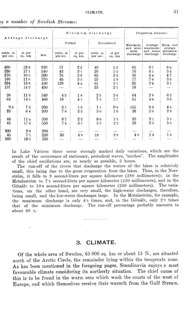
>>! a number of Swedish Streams:
Average discharge M ii i m u m discharge Proportion between :
Xormal Exceptional Maximum and
minimum discharge Average
maximumand mean discharge Mean and average minimum discharge
cubic, m per sec. sl per sq. km mm cubic, m per see. sl per sq. km cubic, m per sec. sl per sq. km
480 19-5 620 57 2-8 40 l’G 65 3-7 8-4
230 17 l 540 42 31 20 1-5 70 41 5-5
370 18-6 590 78 3-9 65 3-3 36 4-4 4’7
160 11-6 370 45 33 25 1-8 77 7-6 3-6
394 13-6 430 128 4-4 61 21 33 2-9 3l
157 14-2 450 - — 23 21 58 — —
26 11-8 340 4’2 1-8 2-5 l’O 64 3-8 6-2
64 14-5 460 18 4-1 75 17 51 4-8 3-6 !
9-3 72 230 2-1 1-6 11 0-8 155 5 9 4-4
23 64 200 7-8 2’2 3-6 1-0 26 2-6 2-9
44 ll-o 350 87 2-2 60 1-5 33 3-1 5-1
41 17-8 550 7-5 31 5-2 2-2 29 2-9 5-5
200 9-0 280 _ _ _ - _
45 7-1 220 30 4-8 18 2-9 45 1-8 1-6
500 10-5 330 — — — — - — 1
In Lake Vättern there occur strongly marked daily variations, which are the
result of the occurrence of stationary, periodical waves, "seiches". The amplitudes
of the chief oscillations are, as nearly as possible, 3 hours.
The run-off of the rivers that discharge the waters of the lakes is relatively
small, this being due to the great evaporation from the lakes. Thus, in the
Norrström, it falls to 9 second-liters per square kilometer (280 millimeters); in the
Motalaström to 7"i second-liters per square kilometer (220 millimeters), and in the
Götaälv to 10*6 second-liters per square kilometer (330 millimeters). The
variations, on the other hand, are very small, the high-water discharges, therefore,
being small, and the low-water discharges large. In the Motalaström, for example,
the maximum discharge is only 4’5 times, and, in the Götaälv, only 2’7 times
that of the minimum discharge. The run-off percentage probably amounts to
about 40 %.
3. CLIMATE.
Of the whole area of Sweden, 65 000 sq. km or about 15 %, are situated
north of the Arctic Circle, the remainder lying within the temperate zone.
As has been mentioned in the foregoing pages, Scandinavia enjoys a most
favourable climate considering its northerly situation. The chief cause of
this is to be found in the warm seas which wash the coasts of the west of
Europe, and which themselves receive their warmth from the Gulf Stream.
<< prev. page << föreg. sida << >> nästa sida >> next page >>